ORLANDO, Fla. – Tropical Storm Isaias is slowly moving closer to Florida’s east coast and weather conditions are starting to turn more rainy and windy.
The storm is currently bringing heavy rainfall and gusty winds to the northwestern Bahamas and is just about 40 miles from Florida’s coast, according to the latest advisory from the National Hurricane Center (NHC).
The center of the storm is expected to move near or over the east coast of Florida. FOX 35 Meteorologist Jayme King expects that it could possibly make landfall at Port Canaveral late on Sunday or early Monday.

TRACK THE TROPICS: Visit the FOX 35 Orlando Hurricane Center for the latest in the tropics, including daily updates, live radar, and severe weather alerts.
Isaias said to be moving northwest at 8 mph with maximum sustained winds near 65 mph. Little change in strength is expected by the NHC. A patch of drier air is expected to keep the intensity of the storm down and it should not regain hurricane intensity.
Advertisement

ACTIVE WEATHER ADVISORIES:
A Tropical Storm Warning is in effect for:
- Hallandale Beach Florida to South Santee River, South Carolina
- Lake Okeechobee
A Tropical Storm Watch is in effect for:
- North of South Santee River, South Carolina to Surf City, North Carolina
A Storm Surge Watch is in effect for:
- Jupiter Inlet to Ponte Vedra Beach, Florida
- Edisto Beach, South Carolina to Cape Fear, North Carolina

WEATHER ALERTS: Download the FOX 35 Weather App to track the tropics on your phone, receive severe weather alerts, and get the latest daily forecasts.
A FOX 35 WEATHER ALERT DAY is in place for the whole weekend.

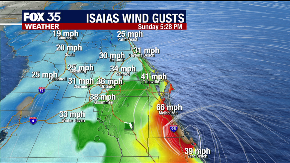
With the latest track, Isaias could make landfall in Port Canaveral. Tropical-storm-force winds are possible in the next 24 hours, primarily in gusts but could become sustained along the coast.

The Brevard County coast is already starting to experience some rain, with high-producing, fast-moving tropical downpours expected when Isaias is closer. Impactful rain bands could come inland as well later in the morning.
Brevard County braces for impact of Tropical Storm Isaias
FOX 35 reporter Matt Trezza gives an update on weather conditions from Indian Harbor beach.
Winds and rain start to pick at Cocoa Beach as Tropical Storm Isaias nears
FOX 35 reporter David Martin gives the latest on the weather conditions at Cocoa Beach.
There is also a slight risk of tornadic activity as conditions continue through Sunday and into Monday morning in Florida.
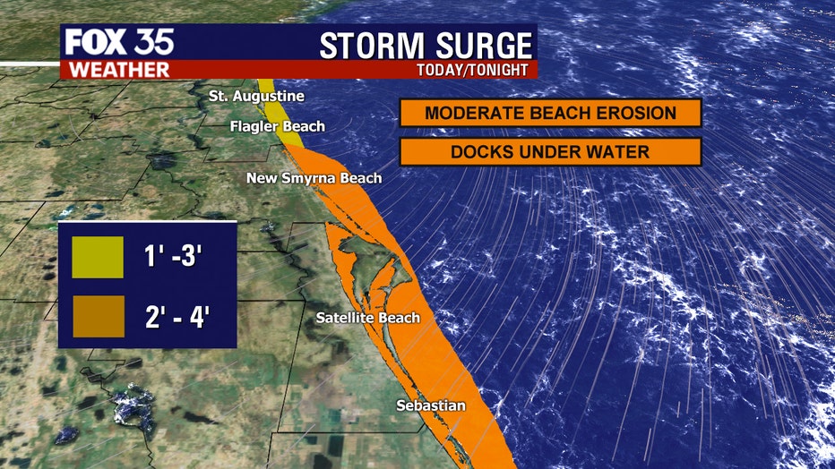
Along the coast, expect a storm surge between one to four feet. This may leave some docks under water and moderate beach erosion behind.

Even though the sustained winds of Isaias are weaker than originally expected, FOX 35 meteorologist Jayme King wants to remind Floridians to stay vigilant as even a tropical storm can still cause severe weather and damage.
STAY PREPARED: Get all you need to know about the 2020 Atlantic hurricane season with the FOX 35 Orlando Hurricane Guide
Tropical Storm Isaias moving slowly as rain and wind pick up in Florida
FOX 35 Meteorologist Jayme King gives the latest on Tropical Storm Isaias.
Isaias was the second hurricane of the 2020 Atlantic hurricane season but has since weakened into a tropical storm.
Isaias has already been destructive in the Caribbean, On Thursday, before it became a hurricane, it uprooted trees, destroyed crops and homes, and caused widespread flooding and small landslides in the Dominican Republic and Puerto Rico. One man died in the Dominican Republic. In Puerto Rico, the National Guard rescued at least 35 people from floodwaters that swept away one woman, whose body was recovered Saturday.
Track the Tropics on the FOX 35 Weather App
FOX 35 meteorologist Allison Gargaro tracks the tropics on the FOX 35 weather app.
CLICK HERE TO DOWNLOAD THE FOX 35 WEATHER APP
Tune in to FOX 35 Orlando for the latest tropical updates.


Comments